
Mani Peninsula - Part III
(Mesa Mani)
(updated September 2020)
DAY III
From Areopoli to Cape Tainaro
. Courtesy of Google maps.")
From Areopoli to Cape Tenaro and back (red line). Courtesy of Google maps.
The drive from Areopoli to Kokkinogia (Κοκκινόγεια), which is the southernmost settlement of continental Europe is about one hour nonstop (via the western road). There are many important villages between these two places. When I visited the area, it was early September and still hot, so I wanted to arrive as early as possible to the tip of the Cape and its famous lighthouse. I drove all the way to Vatheia and then directly to cape Tainaro. On my way back I visited several places.
This trip is long if you want to visit as many places as possible or/and go swimming in the crystal-clear beaches, so it is better to start early.

The rocky coast close to Vatheia.

One of the two beaches at Kapi settlement, close to Vatheia.
Vatheia
Continuing south, the rocky peninsula starts to narrow, as its east and west coasts rush to their meeting. Vatheia (Βάθεια), perched high above the sea, shows just how extraordinary this area once was. While many villages have one or two towerhouses, Vathia sprouts a forest of them. It looks like a medieval fantasy, but clan wars were taking place here, often from one side of the windy streets to another, well into the 19th century.

Vatheia.
Unfortunately, the majority of the buildings, today, are again deserted and it is really very disappointing to see all the money that was spent to have been actually wasted away. Today, only one restaurant-café operates in the village, which offers great views. Just before arriving to Vatheia, at the Kapi settlement, there are two beautiful little bays that form two sandy beaches. Great places for a dive into the deep blue waters of the Messenian Gulf.

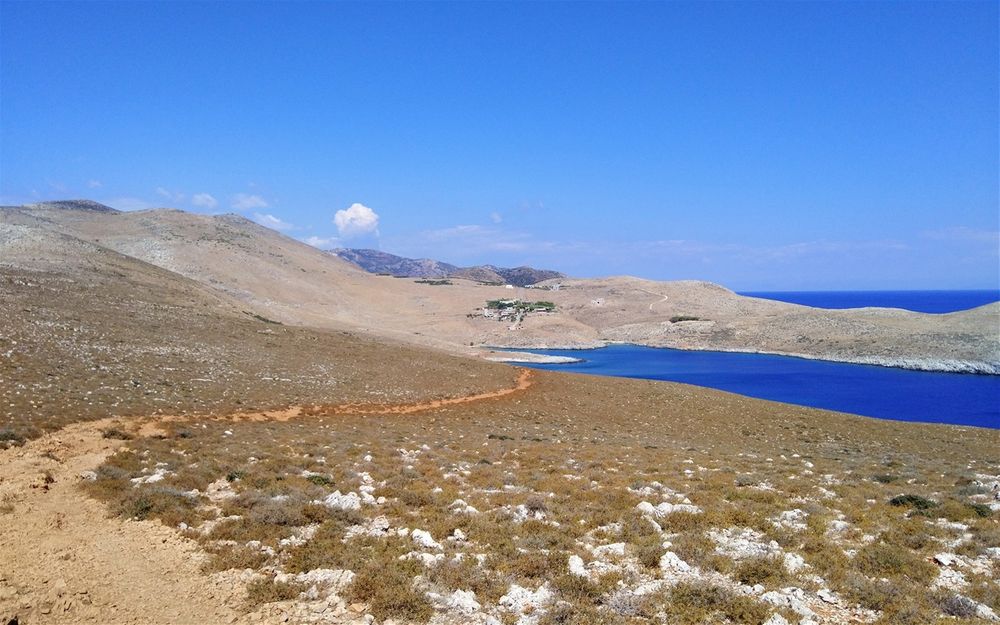
This is the narrowest part of the peninsula is between Porto Kagio and Marmari.
Cape Tainaron
Cape Tainaron (Ακρωτήριον Ταίναρον), also known as Cape Matapan, is the southernmost point of mainland Greece and separates the Messenian Gulf in the west from the Laconian Gulf in the east. Cape Matapan has been an important place for thousands of years. The tip of Cape Matapan was the site of the ancient town Tenarus, near which there was (and still is) a cave that Greek legends claim was the home of Hades (the Underworld), the god of the dead. The ancient Spartans built several temples there, dedicated to various gods. On the hill situated above the cave, lie the remnants of an ancient temple dedicated to the Sea God Poseidon (Νεκρομαντεῖον Ποσειδῶνος). Under the Byzantine Empire, the temple was converted into a Christian church.

Vatheia village.
Vatheia is the most photographed village in Mani and a tourist attraction during spring and summer due to the abundance of wild flowers that cover the nearby hills and its scenic views. Moreover, it serves as an iconic example of the south Maniot vernacular architecture as it developed during the 18th and 19th centuries. Vatheia is first mentioned in 1571, by a Venetian diplomatic mission, as "casale di Vathia". In the 20th century, Vatheia was progressively abandoned by its residents, who emigrated either to Athens or to faraway places. In the 80s the Greek Tourist Board decided to restore the beautiful tower-houses and bring life back to the town. They restored the houses and gave them back to their owners to use them either as residences or hotels.
The coasts almost do meet a bit further down between Porto Kagio and Marmari. The former, on the east coast, is named after the quails which were caught here in outstretched nets, before being shipped out of Gerolimenas. To the west, Marmari has a couple of sandy coves, rare for this rocky coast, and above them sits the aptly named Marmari Paradise Resort offering good value stone-built rooms and a taverna.
.")
The temple dedicated to the Sea God Poseidon (Νεκρομαντεῖον Ποσειδῶνος).

Cape Tenaro.

The lighthouse at the tip of Cape Tainaro.
The entrance to Hades, the gate to the Underworld according to the ancient Greeks, is believed by the locals to be at some caves located at the small fishing cove on the east of the ruins of the Poseidon temple. There is a foot path that takes you down there.
At the very tip of the cape there is a lighthouse, which built by French engineers in 1882 and operated for the first time in 1887. Rrecently the lighthouse has gone through a total renovation. At Cape Matapan, the Titanic's would-be rescue ship, the SS Californian, was torpedoed and sunk by German forces on 9 November 1915. In March 1941, a major naval battle, the Battle of Cape Matapan, occurred off the coast of Cape Matapan, between the Royal Navy and the Italian Regia Marina, in which the British emerged victorious in a one-sided encounter. The encounter's main result was to drastically reduce future Italian naval activity in the Eastern Mediterranean.

The small fishing cove where the entrance to Hades was.
Hades & the Underworld
According to the Greek mythology, this gate of Hades was guarded by Cerberus, a vicious beast that prevented the dead from escaping and the living from entering the world of the dead. According to Apollodorus, Cerberus had three heads of wild dogs, a dragon or serpent for a tail, and the heads of all sorts of snakes all over his back. In his twelfth labor, assigned to him by King Eurystheus, Heracles (Hercules) was ordered to descend to the Underworld, kidnap and bring Cerberus to the surface. He asked Hades’ permission to capture the beast.
. Orpheus descends into the Underworld to recover his wife, Eurydice. Pluto and Proserpina, the god and goddess of the underworld, are so moved by the music of his lyre that they accede to his request. On the right of the picture are Pluto and Proserpina and below them is Cerberus.")
Orpheus and Eurydice by Rubens (1636-1638). Orpheus descends into the Underworld to recover his wife, Eurydice. Pluto and Proserpina, the god and goddess of the underworld, are so moved by the music of his lyre that they accede to his request. On the right of the picture are Pluto and Proserpina and below them is Cerberus.
The lord of the Underworld replied that Heracles could take Cerberus with him as long as he used no weapons and didn’t hurt him. Heracles used his bare hands and was able to overpower the beast. He dragged it out of the Underworld and brought it to Eurystheus. Orpheus also traveled down to Hades to bring back to life his beloved wife, Eurydice, through this cave. Hades himself told Orpheus that he could take Eurydice with him but under one condition; he should not look at her before coming out of the cave, because he would lose her. Unfortunately, only a few feet away from the exit, Orpheus lost his faith as he could not hear his wife’s steps, so he turned to see… Eurydice was immediately sent back to the Underworld forever.

Kokkinogia seen from the south.
Then the road passes by another small bubble beach and continues to the lighthouse uninterrupted. It is supposed the whole path to be only 700m long. I really do not know! It seems to me much longer. Maybe, because it is much more difficult that it seems on the map. From the car to the lighthouse will take a leisurely 40 minutes. Very good trekking shoes are needed for the rocky terrain. Some water and a cap will be certainly very much appreciated by your thirsty sun-burned self!

The last part of the path to the lighthouse.
To visit the lighthouse, you have to leave your car at the end of the road, just above the caves of Hades. Go down to the small but beautiful Tenaro Beach, where you can swim on your way back to clean away all the dust off your tired body. Pass the little beach and follow the red-colored (the soil obviously contains iron, which when is oxidized turns red) path. In about a hundred meters the path passes through a roman villa, where a floor mosaic can still be seen.

The Roman villa at Cape Tenaro.
You may be a bit exhausted, when you arrive at the lighthouse, but the views both on your way there as well as from the yard of the lighthouse are rewarding. Rest for some time before taking the way back. Naturally, the walk back is a little tougher!

Walking to the very end of Cape Tainaro and its lighthouse.
Porto Kagio
I left the cape very tired and I drove up north (there is nothing towards the south, anyway) to the town of Porto Kagio (Πόρτο Κάγιο). Porto Kagio faces a small bay off the Laconian Gulf and is about 5km from Cape Matapan. This picturesque little town was known in the ancient times as Psamathous. The modern name comes from the Venetian Porto Quaglio and the French Port des Cailles (Quail Port).

Porto Kagio beach.
Porto Kagio was the base of Lambros Katsonis's pirate fleet, and it was at Porto Kagio that it was finally destroyed. In World War II, Porto Kagio was a place where many British soldiers escaped to Egypt. Porto Kagio is the perfect place for quite relaxing holidays. The sea is wonderful and there are several taverns to eat and holiday rooms to let.

Porto Kagio.
Some 17th- and 18th-century maps called it "Maina", so some authors consider it to be a possible location for the castle of Grand Magne, but medieval portolans mention no such castle here. The Ottomans built a castle here in about 1568, to protect the port, which was used for galleys patrolling the Kythera Channel. The Venetians attacked the castle in 1570, and the Ottomans surrendered and abandoned it. In 1670, the Ottomans returned and built a new castle. They were driven out in 1770 during the Orlov Revolt.

Porto Kagio.
The very first thing I did when I arrived to the town and parked on the beach itself was to put on my swimming trunks and fall into the calm and warm waters. There were hundreds of little fish that decided to give me a full body peeling!!!

Lunch at the “Akrotiri” tavern.
Lagia
I left Porto Kagio and headed north east to one of the most well preserved villages of Mani: Lagia (Λάγια). Lagio is a very quiet (almost sadly empty) town with stone tower-houses, some of which have the unique shape of pyramidal frustum. I visited the town mostly to see its main attraction, which is “Bey’s Café” or “Kafeneio ton Kynigon”.

Lagia.
We had a beautiful lunch at the “Akrotiri” tavern. The tavern also offers rooms to let at the floor above it. We eat some excellent fried little fish “atherina” …. I believe they were the same little ones who gave me the body peeling earlier… lol. And yes: I had spaghetti meatballs, the same way my mother used to cook them for me… this is what I call “happiness”!

Lagia.
The café is located on the main road and is famous mainly of its fully decorated walls: old, colored or black and white photos hanging everywhere, old paintings showing old ladies, towers, prickly pears, knives, worry beads, walking sticks, shells, sculptures, and much more. The walls are painted with some nice looking portraits and other popular topics. The owners have two sons: a sculptor and a painter, who obviously are responsible for this awesome and bizarre “art gallery”.
Unfortunately, this famous café has been closed for the last couple of years. Only the stories narrated in it still stroll along the whirling roads and waft among the deserted towers like the sunset breeze or lost ghosts.

Lagia.
I went to the other (the only one left) café/restaurant of the town, which is located just opposite the metropolis of the town: the church of Dormition of Our Lady. The “Koinotikon” restaurant feels like a cool and relaxing oasis in the scorching landscape of Mani. We enjoyed our cold “frappe” coffee sitting into soft sofas and listening to beautiful music.

“Koinotikon” restaurant at Lagia's main square.
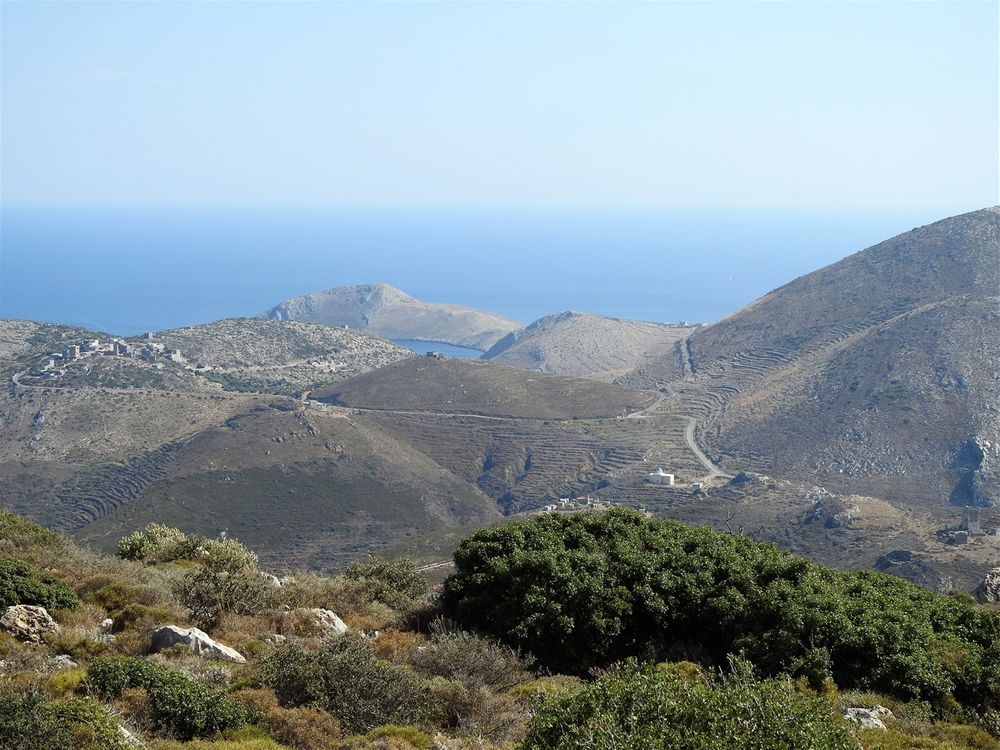
Back to the road heading south and then west towards Gerolimenas. From the road you have great views of Vatheia and the Messenian Gulf.

View of the Messenian Gulf.
Cavo Grosso
If you fancy your chances of locating the shrine to Athena or have a penchant for walking along very rocky paths or indeed would like to meet some local cows, then a visit up to Cavo Grosso is a must. Cavo Grosso is the plateau scattered with small villages between Gerolimenas (south) and Mezapos (north). The views are fantastic – to the north Tigani, Mezapos and beyond to Areopolis, east across the plain to the mountains (and in particular the two towers of Leontaki,s nestling) and south all the way down to Tainaron. The plateau is a labyrinth of ruins and stonewalls, all partially hidden by low growing scrub. You need a good pair of shoes and strong legs if you want to explore much of this fascinating area.
For more about Cavo Grosso, Gerolimenas and Mezapos follow the link here.
Diros Caves
Leave Mezapos behind and drive north on the main road to Areopoli. As you approach the Pyrgos Dirou town, there is no way to miss the signs towards the famous Diros Caves. Drive through the town and at the Kampinares road-fork turn left. On the right the road leads to the beautiful Diros beach. Both the beach and the caves are located at the base of the Diros bay, a quiet, protected gulf.

Diros Caves area. Red line shows the main road from Gerolymenas to Areopoli, while the yellow one shows the detour to the caves. Courtesy of Google maps.
The area around the caves has been developed to cater for the tourists who flock to visit this unique speleological miracle.

Diros bay.
On the small pebbled beach under the caves there are some buildings (they also look very 70s to me) which look neglected. A tourist shop and a tacky café completes the picture. I was feeling very lazy that day, so I did not enter the caves. To tell you the truth I felt a bit uneasy to the idea of getting into a small boat with other naughty tourists wearing salvation jackets. The cave network is the Mani's number one tourist attraction and rightly so. The Diros caves consist of two caves: Alepotrypa and Vlychada.

The entrance to the caves.
The richness and quality of the unearthed findings witness the existence of a populous society in Alepotrypa, which developed over time into an important center that engaged largely in trade, maritime travel, farming and stockbreeding. Strangely enough, human skeletons were found on the surface, meaning that entombment had not taken place.
To me the whole place looked a bit dated, like coming out from a 70s Greek Tourist Board poster; the way it looked when I first visited the place back in 1983 (as a high school student). The tickets to enter the caves you have to buy some 300m before the entrance to the caves. There is a parking in front of the ticket booth, so you buy the tickets and continue with your car to the final destination, where there is also a big parking full of touristic buses.

The cafe by the entrance to Diros caves.
They were explored by the speleologists Ioannis and Anna Petrochilos. The Alepotrypa cavern was discovered in 1958. Archaeological research begun in 1970 under the direction of archaeologist Georgios Papathanassopoulos. In the course of the late Neolithic period (4000 - 3000 BC), the cave was extensively used as shelter, dwelling, workshop, storage place for goods, cemetery and a place of worship.

Vlychada Cave. (Courtesy of "Σπήλαια Διρού" and its official site)
This led archaeologist G. Papathanassopoulos to the conclusion that these Neolithic people died suddenly during a strong earthquake, which in turn generated huge rockslides from the ceiling, thus blocking the cave's entrance. The passageways of Alepotrypa, decorated with stalagmites and stalactites, measure 500 m in length. The cave covers an area of 6,500 m2. The central cave ends in a very beautiful lake attaining a maximum depth of 6 m. The cave is not open to the public, yet. The cave of Vlychada covers an area of 16,700 m2 and since 1949 it was discovered (eventhough the locals new about the cave long before) about 2,800 water passages have been explored. The exploration of Vlychada has yielded fascinating finds, including the fossil of a hippopotamus from the late Pleistocene Epoch, around 32,000 years ago, as well as evidence of panthers, lions, spotted hyenas, ferrets and seals.
A 2.5-km-long winding passageway is the main route for sightseeing. During a 40-min boat trip, the visitor comes across an intricate network of passages and galleries, decorated with gleaming stalagmites and stalactites, whose reflection in the water accentuates their natural beauty. The guided tour into the cavern of Vlychada takes place by boat and on foot - part of it is on land.

Vlychada Cave. (Courtesy of "Σπήλαια Διρού" and its official site)
The official site of the caves is very informative; alas in Greek only!

The memorial statue of the Woman of Mani located close to the entrance of Diros caves. The women of Mani fought the Turks in the Battle of Diros in 1826 by any available means they had, such as sickles, stones and thistles. This is one of the most heroic aspects of modern Greek history.
It has been a very long and tiring day. On your way back enjoy a cold coffee and an ice-cream at Areopoli. Relax and try to digest all these wonderful places you have been visited.
A worth taking detour (Kotronas)

The Kotronas beach.
The road (13km) to Kotronas goes through beautiful landscape of green valleys and bare mountains.

Me relaxing at "Akrogiali" fish tavern in Kotronas.
Kotronas used to be a major commercial port of Mani, but later it was replaced by Gytheio. Several sandy beaches are to be found around the village, but one doesn’t have to go far to look for one, as the best one is in the village itself, next to the port. By the beach, overlooking the pier of the port, there is an elevated memorial little park.
If during your visit to Mani you have some extra time, it really worth taking an extra trip to Kotronas (Κότρωνας). The village of Kotronas lies in a bay of the Laconian Gulf. From Areopoli to Kotronas is only 16 km on a good road that traverses the peninsula from west to east connecting the two towns. From Areopoli take the main road down towards Gerolimenas, and after less than 3km (at Lagokili) take the road on the left towards Kotronas. There is a clear signpost, so you will not miss the turn.
Here stands the statue of Ioannis Demestichas, an hero of the Balkan Wars, who is praised by Penelope Delta in her book “The secrets of the marsh”. Have a stop at the shady veranda of “Akrogiali” fish tavern and watch people at the beach bellow.
Not far from the center of the village and its port, there is a small rocky peninsula called Skopa (Σκοπά). Skopa peninsula is connected to the mainland with an isthmus, which forms two little pebbled beaches at its both sides. There is not a signpost for the “double Skopa beach”: a little road starts at the west end of a playground on the main road of the village. This road is very narrow and a dead-end, so do not drive the car down to the beach. Walk the 400m or ride a bike.

Skopa pebbled beaches, not far from Kotronas center.