
(Argolis part 2)
Nafplio
the Argolis star...
December 2021
Intro
What one can add more about Nafplion? There is so much information about this sublime city available, that feels like there is nothing else left to write or picture. I myself already wrote about Nafplion at a previous post in my travelogue: An autumn long weekend in north-eastern Peloponnese-Argolis
Nevertheless, I decided to give it a try and give my personal view about the city and also suggest some trips not far away from the city, as well as some walks in the city itself. Besides, I will keep this article “open” and add more info in it every time I revisit the city.

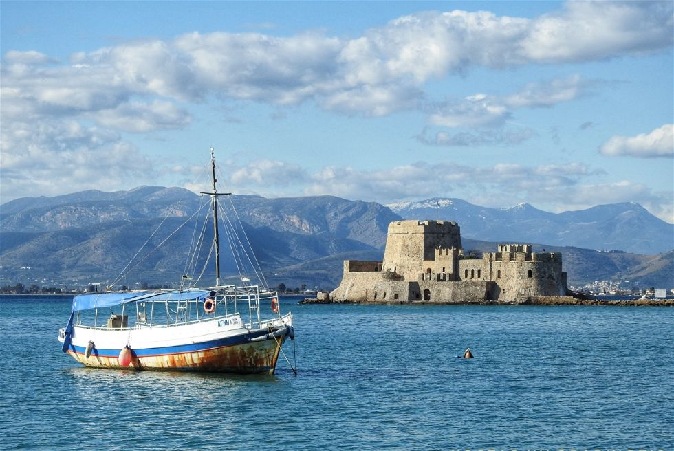
Palamidi fortress on top of a rock overlooking the old town of Nafplion.
In the last couple of years, I visited Naflion several times. The last time it was for Christmas 2021. During this trip of mine, I stayed in Nafplion for a whole week, and spent all days in the city, as I had a back problem and could not drive. In the end, I was very "happy" about this situation because I spent all my time walking around the city and soaking in this unique atmosphere. I visited many restaurants and cafes and tasted several dishes. I stayed at pension "Omorfi Poli" this time, a very well-organized, super-clean small hotel in the old town.

The entrance of DownTown Hotel in Nafplion.
Coffee and food
Nafplion, over the years, has become a culinary paradise and has managed to get away from the usual souvlaki-tzatziki-mousaka triptych. Of course, there are many restaurants that still and mainly cater to tourists, but if you do not feel like having “the best saganaki ever”, there are several good dining places around. Just be adventurous and look around.
During my previous visit, I had the pleasure to sojourn at the hotel: 'DownTown hotel', a new family-run hotel also in the center of the old town. The hotel has been decorated beautifully and has all the modern amenities the guest needs. The ordinary rooms are relatively small but very comfortable and cozy. I had a large room (for an extra cost) with a small balcony and a big sofa.
 there are several cafes and restaurants.")
On the main square (Syntagma Square) there are several cafes and restaurants.
Note: I never include breakfast when I visit a city in my hotel reservation. The reason for this is that I want to go out for breakfast and choose a different place as much as possible every day. I did the same here.

There are several cafes on Syntagma Square.
Another excellent choice is 'Sokaki Cafe'. Sokaki is not located on the square itself, but on the side of the Archaeological Museum of Nafplio, behind the big plane tree on the northwest corner of the square. You are welcomed by an enjoyable environment and an over-the-top decoration, which instead of irritating the guest, somewhat relaxes him. There is a seating area inside and outside, as is usual in Greece.
Ι believe that Central Square is the best place to have your breakfast or a light meal in Nafplion. Syntagma Square is a big square surrounded by beautiful houses and historical monuments. Consequently, it attracts many locals and visitors. So, what is better than having your breakfast here and watching people come and go! I prefer to sit outside, even during wintertime. Usually, I have my coffee or breakfast at XENON Café-Bistro, which serves you tiny greek honey donuts (loukoumades) for free with your coffee!

Sokaki cafe.
The central square is an excellent place to watch people passing by while having coffee. Besides, this is my favorite entertainment when I go out. But, the best location to do this in Nafplio is the part of the port at its western side, under the Akronafplia rock. It is here where everyone is coming to see other people and be seen. There are several cafes here with a beautiful view of the port and the Burtzi islet-castle.

The part of the port, where all the cafes are located.
 and Philellinon Square (bottom).")
Allotino coffee & bar (top) and Philellinon Square (bottom).
For dinner, maybe the best place is the modern '3SIXTY Grill Dining & Wine Bar', which I have described in a previous article: check it here.
Most of the restaurants that are located on the port (the part which is between the Old customs House and the bar "Black Cat" are a good choice (in Boumboulinas street). There is a restaurant here for every taste: Chinese ("Dao"), Italian, Greek traditional ("Wild Duck"), etc.
"Vassilis" is a traditional Greek tavern located in Staikopoulou street, south of Central Square. I was stunned by the food quality they serve.
In the new part of the city, where most locals enjoy their meal, you will probably find more authentic local cuisine. 'Fougaro' is an Art Center located some way from the old town, on the way to Epidavros (Asklipiou Avenue). Besides exhibition rooms and children's playgrounds, Fougaro also has a cafe/restaurant with delicious cuisine.
Do not leave Nafplio without tasting authentic Italian gelato at 'Antica Gelateria di Roma' (Farmakopoulou street). If you are around during the Christmas holidays, here you will find the best pandoro and panettone cakes. Don't miss trying both!
Arvanitia walk
The old city of Nafplion occupies the northern part of a small peninsula, the southern part of which is taken up by the Acronafplia rock and fortress. Indeed, every part of the town is ideal for short or longer walks, but if you want to feel like being on an island away from buildings and crowds, then take the peaceful and scenic walk around the outer part of the peninsula.

Arvanitia is a path that runs the coastline of the peninsula in the old town.
.")
Arvanitia walk (red path).
Arvantia scenery.
From Arvanitia beach, you have to walk another kilometer by following the eastern walls and bastions of the Akronafplia fortress to be back in the center of the old town again.
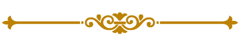
From Arvanitia to Karathona beach

Prickly pears around Arvanitia path.


Arvanitia scenery.
A paved, 1.5 km long path, called Arvanitia road, takes you from the busy harbor and the lighthouse pier to the Arvanitia beach, under Palamidi Fortress. The trail follows the seashore at about 2 meters above it, while the dramatic rocks hang above you. When you are at the tip of the peninsula, you will see a whitewashed little path going up to the little chapel of Panagitsa built in the rock. At Arvanitia, you find yourself among the most beautiful brightly colored prickly pear cacti. There is no other place on earth with so many prickly pears, not even Sicily.
...
The Archaeological Museum of Nafplion
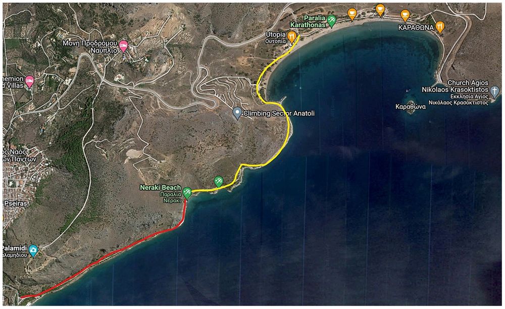
From the beginning of the 1930's, the Archaeological Museum of Nafplion has been housed in the imposing three-storey Venetian building, which forms the western boundary of Syntagma (constitution) Square, the main square of old town. It is one of the most beautiful and best-preserved monuments from the time of the (second) Venetian occupation of the area.
. The Lion of Venice and a fount, all inlaid in the facade (bottom).")
The museum facade. The entrance (top right). The Lion of Venice and a fount, all inlaid in the facade (bottom).
The museum has been recently renovated (2008). Its permanent exhibition is being developed in the upper two floors of the building and is structured in thematic sections that present the cultures developed in Argolis from the prehistory (2nd floor) to the late antiquity (3rd floor). The museum has used all the modern knowledge to develop its exhibition in the most efficient and understandable way. All exhibits have clear information labels in both Greek and English. There is no elevator, but there is a wheel chair lift for those in need. I had visited the museum many years ago, when it was a bit dusty and worn out... I did not expect such a beautiful renovation.
According to the marble inscription inlaid in its facade, the building was built in 1713, during the time of the second Venetian occupation, by the prefect of the fleet, Augustine Sagredo, to be used as a naval warehouse. Following liberation (in the first quarter of the 1800s), it maintained its military character, as it was successively used as a barracks, the headquarters of the 8th Infantry Regiment and a military club.

Exhibits in the Archeological Museum.

The "Lord of Asini", one of the famous exhibits of the museum.
I wanted to visit the museum especially to particularly see two of its exhibits: the famous "Lord of Asini" (ο Άρχον της Ασίνης), the head of a female figurine (from the 12th century BC), not much bigger than a man’s fist; and the major exhibit of the museum, which is the bronze Mycenaean armor (cuirass) from Dendra, which dates from the end of the 15th century BC. The armor is one of the most splendid and impressive samples of Mycenaean defensive weaponry to survive to the present day. There is a projection room in the museum, where they screen a very interesting documentary film about the discovery of the armor from Dendra.
The museum is open every day, except Tuesdays, from 08:30 to 15:30 (more or less, depending of the time of the year) and costs 3 euros during the winter period and 6 euros during the summer period.

The armor from Dendra.
The 2nd Venetian Occupation (1686-1715) period, although really quite short, was of lasting importance for the city. Nafplio, known as Napoli di Romania, became the capital of the Kingdom of Morea (Regno di Morea) and the Venetians hastily proceeded with the fortification of the rock of the Palamidi, building the defensive complex that we can see today, which was a great achievement in the history of fortification.

Syntagma Square from above. The Archeological museum can be seen on the left side of the square.

Unusual ritual masks made of clay.

The Land Gate and Akronafplia fortress at the background.
The fortification of the Palamidi resulted in the downgrading of the Castle of Akronauplia, which, in 1686, by order of the Venetians, was designated for use exclusively by the military. The eastern section of the Castle of Akronauplia, along with the Land Gate in the lower city, were reinforced with the creation of a new bastion, which was given the name of the governor general of the Peloponnese, Grimani (1706).
The 2nd Venetian Occupation
The same governor general gave his name to a building for housing the troops, built in 1706, in the location of what is now the 'Nafplia Palace' complex (the Grimani barracks). In the same year, the arsenal was built, west of the dividing wall. In 1713, the governor general, Agostino Sagredo, had the Sagredo Gate constructed in the north wall of the Roman castle. In 1713, the Naval Warehouse was constructed in Syntagma Square; these days it serves as the Archaeological Museum.

Palamidi fortress seen from the Land Gate.
The Land Gate was built in 1708 and succeeded the earlier gate dating from the first Venetian occupation. It was the only entrance to the city by land and the gate would be closed at sunset. Whoever remained outside after that time was obliged to spend the night outside the city, usually in the Pronia suburb (see bellow).
In front of the gate was a moat filled with seawater, which ran along the eastern wall of the city. Access was only possible via a wooden drawbridge.
The gate was gradually demolished in the late 19th century and the moat was also filled in. Only a few of the gate's architectural structures have survived, such as the stone lion from the crown, which is missing the head, the wings and the tail. There is also the family crest of the commander Grimani, with the date 1708. Recently, the façade of the gate has been reconstructed following a special study of its original form. Near to the left-hand pillar there is a plaque, which has been inlaid into the wall, commemorating the liberation of the city by the Venetian general-in-chief, Francesco Morosini in 1687.
The Land Gate and the moat in front of it.

The Land Gate seen from inside.

The Land Gate
The Lion of Bavaria.
Pronia is a suburb at the east of the city with a totally different atmosphere than the elegant Old Town of Nafplio. No tourists, just locals live their everyday life here, undisturbed from the hordes of visitors. Pronia was a sparsely populated area before the 1800s. After Nafplio’s liberation from the Turks in 1822, a lot of people from Crete came here to enjoy that freedom. It was impossible to find homes for them all in the Old Town, and President Kapodistrias decided in 1828 that small houses should be built and given to them in Pronia. Actually, the name Pronia derives from a Greek word, προνοώ (pronoo), that means providing - in this case provide housing.
.")
The location of the Lion of Bavaria and Agoii Pantes church on the map (right end, highlighted ).
The lion, which is carved into the rock on a monumental scale, seems to be sleeping. The sculptor of this monument was the German, Christian Siegel, who was the first professor of sculpture at Athens Polytechnic University. The model for the work was the Lion of Lucerne, by the famous Danish sculptor, Bertel Thorwaldsen.

The lion of Bavaria.

The park in front of the Lion of Bavaria.
Below the lion there is an inscription in German that informs us that this monument was commissioned by Ludwig of Bavaria, father of Otto (first King of Greece), in memory of the Bavarian soldiers in Otto's escort who died during the typhoid epidemic in Nafplion, which devastated the area between 1833 and 1834. The Bavarians were buried in the graveyard of Aghii Pantes (the little church nearby) and close to the Church Evaggelistria, some 200-300m north-east.
Today, the area in front of the Lion of Bavaria has been turned into a small park with benches, to provide a place to rest during a tour of the city.
Here, in Michael Iatrou Street, between the church of Agoii Pandes (All Saints) and the modern cemetery, stands an exceptional sculptured monument. The monument is known as the “lion of Bavaria” or “the sleeping lion” and dates from 1841.
Agioi Pantes (Άγιοι Πάντες) is a small orthodox church that was built inside the same rock the lion was sculped into, some 50m to the south of it. A rather small but very important church, Agioi Pantes built during the period of the 2nd Venetian domination (1686 – 1715). When the Turks seized the city in 1715, it was the only church left for the Greeks to go. Until 1852 the cemetery of the city used to exist also there and many of the important heroes of the revolution had been buried there. Old gravestones are laid as a floor in the church, and are also used to cover the stairs leading up to the church.

The church of Agioi Pantes.

Gravestones have been used to cover the stairs leading to Agioi Pantes church.
Agoii Pantes church is usually closed, but you can still see how it is partly built into the rocky hill behind. The view from here is spectacular and one can see the Old town and all fortresses.

View from Agioi Pantes church towards Akronafplia fortress.
out of town
Lake - Wetland of Moustos
37km from Nafplion, on the coastal road to Astros, is located one of the two wetlands of Eastern Peloponnese: the Moustos Wetland. It is only 8km south of the town of Paralio Astros and it is a shelter of migratory birds. The flora of the region is also extremely important. The lake of the wetland is supplied with water from springs (that can be visited by the guests) and is lead to the gulf of Astros through two canals.

Birdwatching.

Location of Moustos Wetland on the map.
The environmental importance of the lake is huge.
The water of the lake is brackish and has healing properties because of the sulfides it contains. This water is suitable for those who have rheumatic and other diseases.
It is said that the lake was once the old port of Astros, from where the must has been loaded, since the area was famous for its vineyards in the old days. This is how the lake took its name Moustos (μούστος=must).
.")
The outflow of Lake Moustos waters into the sea (Gulf of Astros).

Moustos wetland.

Moustos Lake.
The area is very well organized and there are several information signs describing the different flora and fauna of the wetland. There are also several birdwatching shelters along the road that leads to the coast.
The road is not paved, but one can drive on it down the coast in a car. Just drive very carefully, as there are several pot holes here and there. The scenery is breathtaking.

Moustos wetland.
The Church of the Koimisi of the Theotokos of Merbaka.
At the south edge of the village of Merbaka (today known as Agia Triada) is located the Franko-Byzantine church of the "Koimisi of the Theotokos" (Dormition of the Virgin), one of the greatest medieval monuments in Greece. Merbaka is located only 9km north of Nafplion (the same road that goes to Tiryns.

The southern side of the "Koimisi of the Theotokos" church.

From Nafplion to Merbaka.
The church is of the complex four columned cross-in-square type, and is built above a three-level crypt, with bulky ancient stone used for its lower section and the cloisonné system used for the upper. The question of its founding and chronology has been at the center of archaeological debate for decades. The most commonly held idea is that it dates from 1280, due to the gothic elements (the extensive use of carved limestone, double pillared arched windows, pillared dome, etc.), as well as the inlaid ceramics on its outside walls, standing out among which are the proto-maiolica cups from south Italy.
 of")
The facade (western side) of "Koimisi of the Theotokos" church.
 on the external walls of the Merbaka church: a sundial, an ancient marble headstone and proto-maiolica cup.")
Decorative details (inlays) on the external walls of the Merbaka church: a sundial, an ancient marble headstone and proto-maiolica cup.
Inside the church, not a trace has survived from the original mural decoration, however, there are murals, mostly in the area of the altar, which likely date from the end of the 14th-beginning of the 15th century, to the time of the first Venetian occupation, among which stands out the rare depiction of Agios Petros, bishop of Argos, on the prothesis (at the altar).
The church, though, is locked and I did not have the time to ask around how to get inside.

The eastern sid of the "Koimisi of the Theotokos" church.
 on the external walls of the Merbaka church.")
Decorative details (inlays) on the external walls of the Merbaka church.
The founder of the church was most likely the Latin archbishop of Corinth, Wilhem von Moerbeke. A leading figure of the time, a scholar and philhellene, he translated ancient Greek writers. In fact, it is speculated that he himself chose the ancient material, in order to symbolise the union of the two Churches, after the Synod of Lyon (1274), in which Moerbeke participated. Quite possibly, it was from him that the village of Merbaka took its name.
Monastery of Agios Demetrios Avgou
The Monastery of Agios Demetrios Avgou (Μονή Αγ. Δημητρίου Αυγού) is built over the Iria valley and at the northern part of Mount Avgo (at a height of 853m). Its location is directly interwoven with the river Rados. The monastery is located some 40-50km from Nafplion and there are two ways to approach it; both of which are quite tricky.
To go there, from Nafplion head east towards the villages of Vivari and kantia. After Kantia, you pass the Karnezeika and then Ano Karnezeika settlements. Then:

The dirt road leading to the entrance of Monastery of Agios Demetrios Avgou.

From Nafplion to Monastery of Agios Dimitrios Avgou in a car.
Eastern approach. After about 1km from Ano Karnezeika exit the paved road on your right and enter into the dirt road that follows the valley and the river Rados.
👍If you are into trekking/walking, leave the car here and continue walking for about 6.5 km of beautiful scenery.
👎If you have a good 4x4 car or a pickup, you may want to try and drive, at your own risk, all this way to the monastery.
 towards Avgou Monastery.")
The road sign (after you pass Ano Karnezeika settlement) towards Avgou Monastery.
The dirt road from Pelei village to Avgou Monastery.
.")
The 6.6 km walking distance to the Avgou Monastery (Eastern approach).

Western approach. If you have an ordinary car (I have a new Fiat Panda, which is quite tall), then do not take the dirty road I discribed above. Instead, continue on the paved road for another 14km. At the end of this road turn right on a similar paved road, which is the provincial road Lygourio-Porto Cheli. Continue on this road for 5-6km and be aware not to miss the blue road sign, which prompts you to turn right towards the village of Pelei (Πέλεη), and the brown sign for the Monastery of Agios Demetrios. Turn here and pass through the village.

The western approach to the Avgou Monastery, through Pelei village.

Pelei village is small and almost neglected, but very picturesque.
After the village (Pelei), the 7 km-dirt road has sharp rocks here and there. So, drive very carefully and slowly. There is no way to miss the monastery as there are several signs on your way there, some of them just little white boards with handwriting on them.
Outside the gate of the monastery there is a flat area with dirt and grass, where you can park easily your car (there is also a big sign here, so you are sure you have arrived...).

A neglected house at Pelei village.
 Monastery. The picture at the top right shows the")
Road signs to Avgou (Avgo) Monastery. The picture at the top right shows the "parking lot" outside the monastery.
No matter how difficult it is to go there, you will be rewarded from the beauty of the suroundings and of the monastery when you arrive. This remarkable monastery is built into the steep rock where, when looking down, you can see the ravine leading to Iria. and in good visibility you even have a view of the sea. The monastery was neglected till a couple of years ago, but today there is one monk (Monk Georgios Sotirios) living there alone, with his two dogs and 3 cats (at the time I visited). The noisy dogs will welcome you as soon as you enter the metal gate of the complex.

Monk Georgios Sotirios and his dogs welcome the visitors.
The dog barks will prompt the monk to welcome you in turn. He is a very polite young man, who decided to live here alone and to start renovating and built the monastery slowly slowly without much help from the official church or other people.
 the terrace of the building; (bottom right) the dome of Agios Dimitrios church; (top left) Agioi Theodoroi church; (bottom middle) Agios Demetrios church; and (bottom left) the narrow stairs leading inside the monastery building.")
Different views of the monastery: (top right) the terrace of the building; (bottom right) the dome of Agios Dimitrios church; (top left) Agioi Theodoroi church; (bottom middle) Agios Demetrios church; and (bottom left) the narrow stairs leading inside the monastery building.
Another legend says that the name "Egg" comes from the effort of Christians of the time to correctly confirm the place of the monastery to be built. They threw an egg down the cliffs at several candidate locations. All eggs broke. But, when they threw an egg from the location, where the monastery stands today, it did not break! Also, some locals remember a story with two mothers who had each of them a sick child and prayed to the Virgin to heal them. Our Lady told them to "throw the children on the cliffs and they will be cured".

The residence of the monk is a separate building.
There are several local stories and legends about the monastery which try to explain the reason this steep location has been chosen, as well as how the monastery took its name, "Avgou" (Avgo-Αυγό means egg in Greek). Originally, it is said, the founders wanted to build the monastery elsewhere on more even grounds, but Saint Demetrios had a different view. So, the craftsmen started to build the monastery at a different location, but their tools were kept moving to the site that Saint Demetrios wanted! Finally, it was the saint who won and the monastery was built at the current location.

The facade of the monastery.
One of the mothers threw her child on the rocks, the child survived and cured. The other mother, who did not have obviously a strong faith, thought of throwing an egg first to see if it would break. She throws it and it does not break. Then she throws her child and it is killed.
What is the moral that can be derived from a story? Never question the divine orders!
"The Prophet" - Official Trailer (directed by Dimitris Poulos)
Part of the Greek film "The Prophet" shot at Avgo Monastery.
Apart from the stories that have survived, there is no bibliographic reference for the year of foundation of the monastery.
Only from the masonry and especially from the construction of the katholikon (church) with bricks, we can conclude that it is probably an 11th or 12th century building. The main building of the Monastery, built on the rocks, consists of the ground floor and two other floors. The floors are connected by a narrow stone staircase. On the second floor is the monastery's katholikon, which consists of two (side by side) temples: the southern one carved in the rock is dedicated to Saint Demetrios the Myrovlitis and the northern one to Agioi Theodoroi.

Agioi Theodoroi church.

The Saint Demetrios church built into the rock.
Unfortunately, the interior of the church of Agios Demetrios was destroyed by a fire. The fire destroyed the wood-carved iconostasis of the temple, as well as its hagiography.
The two temples communicate with a double-opening, which was painted in the 17th century. The church of Agioi Theodoroi must have been painted at the same time, as is shown by the few hagiographies that remain in the church.
The cave building of the Monastery, according to sources, in around 1700, was home to 16 monks, 16 servants and a big livestock (127 horses, 3000 sheep, 800 goats, etc). The records of the Monastery were destroyed by the 1825 fire set by the Ottomans and in 1835 it was neglected all together.

The valley and the river Rados, seen from the monastery.

The monastery pets.

Monastery flora.
A stone staircase leads to the roof of the Monastery. The view of the plain of Iria from this point is astonishing.
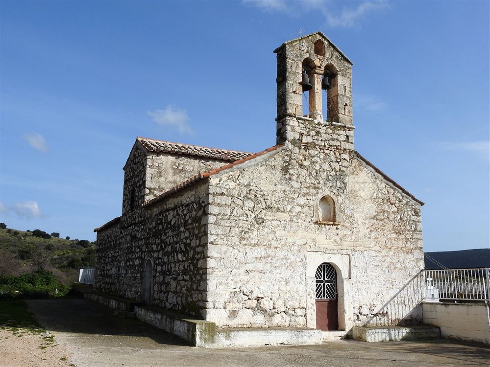
Church of Agios Nikolaos
On the way back from the moastery to Nafplion, on the country road Nafpliou-Trachias and just before the turn towards Iria, you can stop to see the church of Agios Nikolaos. The church of Agios Nikolaos has survived in the north part of Iria, close to the remains of a fort. The church is a single-aisle cross-shape, with two crossing arches which create the form of a cross at the roof. This specific architectural type is found in churches in Argolis from the 13th century on.

Agios Nikolaos vhurch is located in a fertile plain.
The few remaining murals which decorate the church's interior, belong to the time of the second Venetian occupation.
North of the church there are the ruins of a medieval village and of a tower (Agios Nikolaos Tower). The abandoned tower has a Venetian design and was built in the 14th century. Today, only the south wall remains, which has a width of 1.10 meters and is build out of rough stones.
Asini
10 Km south-east of Naflion is located one of the most important archeological sites of the area: the acropolis of ancient Asini or Asine (Ἀσίνη). The site is known mostly because of the poem “King of Asini” by the Greek Nobel Laureate in Literature, Giorgos Seferis.

The red line shows the road from Nafplion to Asini. The orange line shows the road from Asini to Delfini tavern.
Asini was an ancient coastal Greek city. It is mentioned by Homer in the Catalogue of Ships (νεῶν κατάλογος - an epic catalogue in Book 2 of Iliad, which lists the contingents of the Achaean army that sailed to Troy), as one of the places subject to Diomedes, king of Argos. It is said to have been founded by the Dryopes (Δρύοπες), who originally dwelt on Mount Parnassus.

A map of the Asini acropolis, located inside the archeological site.

Press installation at the archeological site of Asini.
The Asini acropolis seen from afar.

The ticket building of the archeological site of Asini, is housed in a small WWII building.

In one of the early wars (740 BC) between the Lacedaemonians and the Argives, the Asinaeans joined the former when they invaded the Argive territory under their king Nicander; but as soon as the Lacedaemonians returned home, the Argives laid siege to Asine and razed it to the ground, sparing only the temple of the Pythaëus Apollo. The Asinaeans escaped by sea; and the Lacedaemonians gave to them, after the end of the First Messenian War, a portion of the Messenian territory, where they built a new town (also named Asine).
.")
View of Roman Baths of the lower town (4th-5th century AD).

The visitor's trail in the archeological site is well built and easy to be followed.
Nearly ten centuries after the destruction of the city, its ruins were visited by famous traveler Pausanias, who found the temple of Apollo still standing.
Asini is located near the town of Tolon, a modern beach resort, known mainly because of its proximity to Nafplion and its beaches. Excavations made from 1922 by Swedish archaeologists led by Axel W. Persson (and involving the then Crown Prince Gustav Adolf of Sweden) found the acropolis of ancient Asine surrounded by a Cyclopean wall (much modified in the Hellenistic era) and a Mycenaean era necropolis with many Mycenaean chamber tombs containing skeletal remains and grave goods.

At the top of the Asini acropolis.

The Roman cistern.
They found, among other artifacts, 25 tombs, including nine vaulted dome graves. Exclusive objects were placed in the tombs to follow the dead to Hades, including the famous "King or Lord of Asini" _a figurine head that doesn’t depict a king but a woman. She, along with other findings from the area, is on display at the Archaeological Museum in Nafplio, as I wrote earlier in this article.
Excavations have continued since the 1920s almost continuously under the Swedish Institute at Athens.

The Church of the Dormition of the Virgin Mary is located inside the archeological site. Adjacent to the church is the museum/multimedia building.

PIctures of the excavations in the 1920s.
The acropolis (also known to the locals as Kastraki, meaning little castle) is located on a rocky hill, which during the ancient times was almost an island, as the sea waters were surrounding most of it. Today, it forms a small peninsula. There are two gates to the acropolis; the main gate is in the north and the secondary gate is in the east. The walls were restored both in the Early Byzantine and in the Second Venetian Domination periods. The site was last used as a fortified position by Italian troops during the Second World War when machine gun nests were built.

View of Grand Tower, located on the eastern side of the acropolis, on the beach.

View from the Acropolis.
The work on modernasing the archaeological site was completed in 2015. At part of this project the eastern ancient gate was re-constructed (the entrance to the site, today), stairs and pathways for visitors were either constructed or repaired, metal steps and footbridges were placed in areas on the route that were difficult to access, the remains of the monument were displayed and reconstructed, informative signposts were placed around the site, rest stops with seats were created, roofs were placed over mouths of wells and cisterns.
Three later buildings (built during the WWII) were re-constructed and put into new use. One was used for the new ticket office/museum shop for the archaeological site, one for an exhibition on the history and methodology of the excavation process and the third a multi-media room, where there are digital tour applications (digital map, timeline, a visual history of the area, a three dimensional depiction of the baths and 2 short videos on the subject of the Italians in Asini and on the Swedish excavations).
. The footprint of")
The reconstructed eastern ancient gate is today the entrance to the site (left). The footprint of "House G", the biggest house discovered in ancient Asini (right).
You can visit the ruins of a Roman bath, Hellenistic bastions, fortifications, and a cavern made by the Italians during WWII. But, above all, the small promontory is excellent for a refreshing stroll.
Entrance to the archeological site is free.
An extra bonus is the view towards both the countryside and the Argolic bay, especially beautiful in the spring, with a plethora of wild flowers in the lush grass.

Looking towards the countryside from atope the Asini acropolis. The conical rock is the hill of the prophet Elias on top of which stands the little chapel.

A path on the western part of the acropolis.
From the acropolis, looking back towards the countryside you will see a tall conical hill standing very near the modern village of Asini. Long steps take you at the top of the hill, where the little Chapel of Prophet Elias stands. The view is unique, so if you have time climb up "the back" of the hill to feel like flying over the orange orchards of the plain that spreads around the hill. It takes about half an hour to climb to the top and it is maybe not as challenging as it seems, but you need to be in a reasonably good shape. Visit the church and ring the free-standing bell, because that is what you're supposed to do!
Fish taverna "To δελφίνι".

At the fish taverna "Το Δελφίνι".

Vivari lagoon.

At the eastern end of the ancient acropolis starts the 2km-long sandy Drepani beach. Further east, one can visit the green Vivari lagoon, and stop at the “To δελφίνι” fish tavern, located on the eastern side of the lagoon, on the main road to Kantia. This is the perfect spot not only to enjoy delicious fish and sea food, but also for some relaxation by the sea.

Drepani beach seen from the top of the Asini acropolis.
The King of Asini By George Seferis
Translated by Edmund Keeley
’Ασíνην τε. . . — ILIAD
All morning long we looked around the citadel/ starting from the shaded side there where the sea/ green and without lustre — breast of a slain peacock/ received us like time without an opening in it./ Veins of rock dropped down from high above,/ twisted vines, naked, many-branched, coming alive/ at the water’s touch, while the eye following them/ struggled to escape the monotonous see-saw motion,/ growing weaker and weaker.
On the sunny side a long empty beach/ and the light striking diamonds on the huge walls./ No living thing, the wild doves gone/ and the king of Asini, whom we’ve been trying to find for two years now, unknown,/ forgotten by all, even by Homer,/ only one word in the Iliad and that uncertain,/ thrown here like the gold burial mask./ You touched it, remember its sound? Hollow in the light/ like a dry jar in dug earth:/ the same sound that our oars make in the sea./ The king of Asini a void under the mask everywhere with us everywhere with us, under a name:/ ‘’Ασíνην τε. . .’Ασíνην τε. . .’ and his children statues/ and his desires the fluttering of birds, and the wind/ in the gaps between his thoughts, and his ships/ anchored in a vanished port:/ under the mask a void.
Behind the large eyes the curved lips the curls/ carved in relief on the gold cover of our existence/ a dark spot that you see travelling like a fish/ in the dawn calm of the sea:/ a void everywhere with us./
And the bird, a wing broken,/ that flew away last winter — tabernacle of life/ and the young woman who left to play/ with the dog-teeth of summer/ and the soul that sought the lower world gibbering/ and the country like a large plane-leaf swept along by the torrent of the sun/ with the ancient monuments and the contemporary sorrow.
And the poet lingers, looking at the stones, and asks himself/ does there really exist/ among these ruined lines, edges, points, hollows and curves/ does there really exist/ here where one meets the path of rain, wind and ruin/ does there exist the movement of the face, shape of the tenderness/ of those who’ve waned so strangely in our lives,/ those who remained the shadow of waves and thoughts with the sea’s boundlessness/ or perhaps no, nothing is left but the weight/ the nostalgia for the weight of a living existence/ there where we now remain unsubstantial, bending/ like the branches of a terrible willow tree heaped in unremitting despair/ while the yellow current slowly carries down rushes uprooted in the mud/ image of a form that the sentence to everlasting bitterness has turned to stone:/ the poet a void.
Shieldbearer, the sun climbed warring,/ and from the depths of the cave a startled bat/ hit the light as an arrow hits a shield:/ ‘’Ασíνην τε. . .’Ασíνην τε. . .’. If only that could be the king of Asini/ we’ve been searching for so carefully on this acropolis/ sometimes touching with our fingers his touch upon the stones.
Asini, summer ’38—Athens, Jan. ’40

Georgios Seferis and one of the pictures he took himself, during his 1938 visit in Argolis.