

Roman Agora of Athens
(Ρωμαϊκή Αγορά- Forum Romanum)
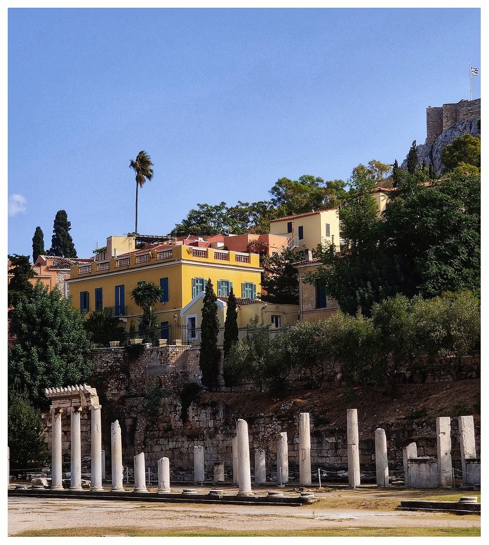
The Roman Agora (Ρωμαϊκή Αγορά in Greek, Forum Romanum in Latin) at Athens is located to the north of the Acropolis and the east of the Ancient Agora. The archaeological site of the Roman Agora should not be confused with that of the Ancient Agora or Hadrian's Libary, which are nearby but are different sites altogether.

The Roman Agora in the colors of sunset.
The Roman Agora was the city's focus of public and commercial life. It was built between 19 and 11 B.C. with the donation of Julius Caesar and Augustus. The Roman Agora was much more than a marketplace, although there were many traders in the courtyard, selling exotic wares that they had brought by ship to the port of Piraeus. There were hairdressers, artists, entertainers, and bankers too. Merchants and local dignitaries regularly met there to discuss local events and negotiate business deals. The Roman Agora was also the regular meeting place for political gatherings. During the reign of Hadrian, the court was paved with slabs.
. The Hadrian's Library (blue bordered) to the north and the Ancient Agora (green bordered to the west).")
The vicinity of Roman Agora (red border). The Hadrian's Library (blue border) to the north and the Ancient Agora (green border to the west).
During the second half of the first century BC, the space within the ancient Agora was reduced due to the erection of Roman buildings. A prominent example was the construction of the Odeon of Herodes Agrippa. Given that the Romans had seized the commerce and trade that was the driver of the Greek Agora, and as the ancient Agora could no longer offer the space required for commerce, the Romans constructed their own Agora between 19-11 BC in the form of a building that had not previously been erected in Athens. Thus, the administrative and commercial center of the city was transferred from the Ancient Agora to the Roman Agora and the Library of Hadrian.

Structional elements of the buildings in the Roman Agora.
The area where the new building was founded was Strabo, called Eretria. The place was previously used as an open marketplace like many other places around the Ancient Agora. These open markets hadn’t specific boundaries, and their names were determined by the goods sold there: Fish-market (ιχθυόπολις), cloak market (ιματιόπολις), etc.
The ancient literacy sources do not mention the monument. It is a mystery why Pausanias, the ancient traveler (2nd century A.D.) who had visited and described with all details the Ancient Agora and Hadrian’s Library, mentions nothing about the Roman Agora. This can be explained by Pausanias’ main aim was to describe the ancient buildings associated with the history, the cults, and the ancient legends of Athens and had no interest in describing the everyday buildings.
. The south colonnade (right).")
The East Gade (left). The south colonnade (right).
During the Byzantine period and the Turkish occupation, the area was covered with houses, workshops, churches, and the Fethiye Mosque. The Greek Archaeological Society started a series of excavations as early as 1837 and continued till 1991. Many private homes and other buildings covering the area had to be demolished for these works to be carried out. In the 1920s, temporary shelters were constructed to house refugees from Asia Minor. These were dismantled before the 1931 excavations.
More recently, the Fethiye Mosque went through a total restoration (that caused a controversy among the archaeologists, architects, and other Athenians because of the materials used, which are not up to the highest archeological standards). The mosque is not open to the public, though, and is not accessible at all.
. The Gate of Athena Archegetis (right).")
A flower blooming among the marbles of the East Gate (left). The Gate of Athena Archegetis (right).
The heart of the Agora is a large rectangular building measuring 110m x 104 m, with an open courtyard surrounded by an Ionic colonnaded portico with shops, storerooms, and offices located in the rear of the portico. The shops had a depth of 6m. The portico (known as the peristyle in ancient Greek architecture) is a covered area outside the shops for people to move around, protected by the sun and the rain. The peristyle columns were of the Ionic order with a smooth shaft. The peristyle comprised a spacious rectangular courtyard 82 m. by 57 m. flagged in marble.
The Roman Agora in Athens was built to a height above the Agora’s eastern propylon level. It was constructed of ashlar masonry, a process by which all stones are worked to have the same shape, size, and surface texture. The working is required to remove the variation in surfaces due to the fracturing of the limestone and marble surfaces when quarried. The advantage of using ashlar masonry is that when horizontal walls were built from masonry units that were flat and smooth, they bonded more tightly by adding a minimum of mortar. The resulting edifice was stronger as a result.
 and the east colonnade (right) of the Agora building.")
The south colonnade (left) and the east colonnade (right) of the Agora building.
The Roman Agora was connected to the ancient Greek Agora to the west by a marble pathway. Coming from the Ancient Greek Agora, one entered the Roman Agora through a Doric propylon known as the Gate of Athena Archegetis. On the opposite side of the building was another Gate, the East Gate. The two gates were placed, one opposite to the other but not at the exact middle axon of the building. This was to align the West Roman Agora Gate with the East Ancient Greek Agora Gate.

Epaminonda street, and the West Gate
Today, the archeological site covers only half of the original building. It includes only half of the west and east colonnades and does not include the north collonade of the Agora. On the northeast side of the archeological site, just across Pelopida street, there is a plot known as "Kalamia" (reeds) due to a former reed basket workshop, which preserves remains of the two neighboring and most important roman monuments of the area, the Roman Agora and the Library of Hadrian, which were separated by a street 10m. wide, running E.W. At the southern end of the plot, the corner of the Roman Agora's colonnade facing northeast, as well as part of the Roman Agora's marble-paved courtyard and its northern precinct wall, are preserved. Remains of the late Roman drainage system are visible in the eastern colonnade.

The South colonnade of the Agora.
Notable buildings
. The blue rectangular shows the limits of the original colonnade of the Agora.")
The Roman Agora archaeological site (red line). The blue rectangular shows the limits of the original colonnade of the Agora.
The most important monuments of the site are:
- The Gate of Athena Archegetis (Πύλη της Αρχηγέτιδος Αθηνάς) stands on the west side of the Roman Agora. The Gate is certainly Roman, but not all Greek tradition and design elements were abandoned in its construction. It was constructed in 11 B.C. with the donations of Julius Caesar and Augustus and was dedicated by the People (Demos) of Athens to their patroness, Athena Archegetis (Αθηνά Αρχηγέτις). The monumental entrance has four Doric columns (a tetrastyle) and a socle made of Pentelic marble.

A dedicatory inscription (on the above part of the tetrastyle) offers an insight into the time and circumstances of the monument's construction: "O ΔΗΜOΣ ΑΠO ΤΩΝ ΔOΘΕΙΣΩΝ ΔΩΡΕΩΝ ΥΠO ΓΑΙOΥ ΙOΥΛΙOΥ ΚΑΙΣΑΡOΣ ΘΕOΥ/ ΚΑΙ ΑΥΤOΚΡΑΤOΡOΣ ΘΕOΥ ΥΙOΥ ΣΕΒΑΣΤOΥ/ ΑΘΗΝΑ ΑΡΧΗΓΕΤΙΔΙ ΣΤΡΑΤΗΓOΥΝΤOΣ ΕΠΙ ΤOΥΣ OΠΛΙΤΑΣ ΕΥΚΛΕOΥΣ ΜΑΡΑΘΩΝΙOΥ/ ΤOΥ ΚΑΙ ΔΙΑΔΕΞΑΜΕΝOΥ ΤΗΝ ΕΠΙΜΕΛΕΙΑΝ ΥΠΕΡ ΤOΥ ΠΑΤΡOΣ ΗΡΩΔOΥ ΤOΥ ΚΑΙ ΠΡΕΣΒΕΥΣΑΝΤOΣ/ ΕΠΙ ΑΡΧOΝΤOΣ ΝΙΚΙOΥ ΤOΥ ΣΑΡΑΠΙΩΝOΣ ΑΘΜOΝΕΩΣ (IG II3 4 12)" (The People of Athens from the donations offered by Gaius Julius Caesar the God and the Reverend Emperor son of God To Athena Archegetis, on behalf of the soldiers of Eukles from Marathon, who curated it on behalf of his father Herod and who was also an ambassador under the archon Nicias, son of Sarapion, from the demos of Athmonon).

The entrance to the archaeological site of Athens Ancient Agora. Gate of Athena Archegetis. The inscription is hard to make out in the photo but is on the row of blocks above the top of the columns.

The Gate of Athena Archegetis.
- Τhe East Propylon (Ανατολικό Πρόπυλο). The east entrance to the Roman Agora had a row of four Ionic columns made of gray Hymettian marble. It was built in 19-11 B.C. to provide access from the eastern side. Today, the eastern Propylon has lost much of its vertical profile. Still, its existence can be established through aerial photos that show the footprints left by the massive columns that supported it.
A third entrance was available from the southern side of the Agora. A small set of five steps flanked by vertically arranged slabs ascended to a terrace below a street-level entrance above the southern retaining wall.

The East Propylon.

The East Propylon in the foreground.
- Fethiye Djami (Τζαμί Φετιχιέ). This Turkish mosque lies on the north side of the Roman Agora. It was constructed in 1456 A.D. on an Early Christian basilica (from the middle Byzantine period (8th/9th centuries).
The basilica was converted into a mosque in 1456/58, soon after the Ottoman conquest of the Duchy of Athens, to coincide with the visit to the city by Sultan Mehmed, the Conqueror, in 1458. Only a fragment of the mihrab survives from this mosque (it can be seen today on the northeast side of the mosque), which was demolished and replaced by the present structure between 1668 and 1670.
The new mosque comprises a porch and a large rectangular main hall crowned by a central dome supported by four pillars. Five arches support the porch, each crowned by a small dome, resting on masonry on the sides and four pillars in the middle. The central dome is flanked by half-domes on each side and smaller domes on each corner.

Fethiye Djami. On the right of the picture can be seen the only part of the original structure that was demolished between 1668 and 1670.
 survives today.")
Only a fragment of the mihrab from the original mosque (it can be seen today on the northeast side of the mosque) survives today.

The East Gate and Fethiye Djami seen at the background.
During Ottoman times, it was commonly known as the "Wheatmarket Mosque" (Τζαμί του Σταροπάζαρου). During the brief occupation of the city by the Venetian forces in the Morean War (October 1687 – May 1688), the mosque was converted by the Venetians into a Catholic church dedicated to Dionysius the Areopagite (the patron saint of Athens who is revered as the protector of the Judges and the Judiciary).
Following the Greek War of Independence in 1824, the disused mosque was used as a school by the Filomousos Eteria of Athens ("Friends of the Muses"). At about the same time, or shortly after the war's end, the mosque's minaret was torn down. From 1834 until the early 20th century, it was used successively as a barracks, a military prison, and finally, as a military bakery. At this point, additions were made to the building to house the bakery's kilns.
.")
Fethiye Djami (the facade).
Since the early 20th century, it has been used mainly as a storage place for various finds from the excavations in the Agora and the Acropolis of Athens. Except for removing recent additions and the restoration to its original shape in 1935, the mosque has never undergone a complete restoration, and by 2010 had developed severe structural problems. In the autumn of 2010, the Greek Ministry of Culture ordered the emptying of the building from the various antiquities stored there and the beginning of restoring it. The decision was sanctioned by Greece's Central Archaeological Council in 2013, paving the way for its restoration and its opening to the public as a space for cultural events. Following extensive restoration and renovation, the mosque was finished in 2017 but never opened to the public, and since then, it has been closed.
On the eastern side of the East Propylon, a staircase led to a naturally higher level on the top of which were built three buildings connected directly to the Roman Agora. Those buildings were the (so-called) Agoranomeion, the Vespasianae, and the Tower of the Winds or Kyrrestos’ Horologion.

The East Gate and the buildings beyond the Agora.
- Agoranomion (Αγορανομείο) was a rectangular building to the southeast of the Roman Agora, dated to the 1st century A.D. and was most probably market inspector's office (this identification is no longer accepted). Today, the so-called Agoranomion has preserved the facade with three doorways with arched lintels and its broad stairway. A big part of the building's eastern side is beneath Markou Aureliou Street; hence, we cannot complete its ground plan. An inscription on the architrave mentions that the building was dedicated to the Divi Augusti and Athena Archegetis. So, it might be identified with the Sevasteion, a building for the emperor's worship.

The Agoranomion.
- The public latrines (Βεσπασιανές-Vespasianae). The Romans thoughtfully provided a 1st Century AD Public Latrine at the eastern end of the Agora (today, adjacent to the east side of the mosque. The building, lobby, and hall were all rectangular, containing a bench with round holes. The space was roofed but for a portal for light and daresay ventilation. It worked in a straightforward and practical running water system, which flushed away the waste products through a deep peripheral canal to the city's main drain. Of course, the Romans were never overly sensitive about bodily functions, so privacy was not a criterion, as the images indicate. It reminds me of the old public toilets seen everywhere in Chinese cities (😲).
 can be seen in the foreground. The Tower of the Winds stands behide them, and the Acropolis can be seen at the background.")
The public restrooms (Vespasianae) can be seen in the foreground. The Tower of the Winds stands behind them, and the Acropolis can be seen in the background.
- The Tower of the Winds (Αέρηδες). The Tower of the Winds or the Horologion of Andronikos Kyrrhestes is an octagonal Pentelic marble clocktower that functioned as an horologion or "timepiece." It is considered the world's first meteorological station. Unofficially, the monument is also called Aerides (Αέρηδες), which means Winds. The structure features a combination of sundials, a water clock, and a wind vane. The architect and astronomer Andronicus of Cyrrhus (in Macedonia) around 50 BC supposedly built it. Still, according to other sources, it might have been constructed in the 2nd century BC, well before the rest of the Agora. In the summer of 2014, the Athens Ephorate of Antiquities began cleaning and conserving the structure; restoration work was completed in August 2016.
. The arches in the foreground belong to the Agoranomion.")
The Tower of the Winds is seen from Lisiou street (north). The arches in the foreground belong to the Agoranomion.
The Horologion is an octagonal tower of Pentelic marble standing on a base with three steps. It has a conical roof, a cylindrical annex on the south side, and two propyla. The 12-meter-tall structure has a diameter of about 8 meters (it is much more spacious than it looks from the outside).
.")
General view of the Tower of the Winds, from Stuart & Revett's 'The Antiquities of Athens' (1762).
The Tower floor is constructed from what appears to be 16 marble slabs laid to complement the structure’s octagonal geometry. The walls are marble, and the fully preserved roof of the building consists of twenty-four slabs. The slabs converge to a circular keystone, ensuring that any forces that arise due to the mass of the ceiling or walls are summed at a central location to enhance stability. A Corinthian capital rests on the assembly and possibly serves as the base of a bronze wind vane in the form of a Triton that indicated the wind direction.
Below the frieze depicting the eight wind deities—Boreas (N), Kaikias (NE), Apeliotes (E), Eurus (SE), Notus (S), Lips (SW), Zephyrus (W), and Skiron (NW)—there are eight sundials.
.")
The marble roof of the Tower of the Winds (interior).

The Tower of the Winds seen through the western colonnade of the Agora.
In the Tower's interior, a water clock (or clepsydra) was driven by water coming down from the Acropolis. Research has shown that the considerable height of the Tower was motivated by the intention to place the sundials and the wind vane at a visible height on the Agora, effectively making it an early example of a clock tower and according to the testimony of Vitruvius and Varro, Andronicus of Cyrrhus designed the structure. The Tower's columns bore capitals of a design now known as "Tower of the Winds Corinthian," although they lack the volutes ordinarily found in Corinthian capitals.
The Horologion was used as a church from the Late Byzantine period (13th-14th centuries AD).
In the middle of the 18th century, as a tekke (monastery) of Ottoman whirling dervishes. It was buried up to half its height at that time, and traces of this can be observed in the interior, where Turkish inscriptions may be found on the walls. The Archaeological Society of Athens thoroughly excavated it in the 19th century.
.")
Ottoman dervishes in the Tower of the Winds (early 19th-century drawing).

The tower of the Winds in a winter's evening. In the background, one can see the snowcapped Mount Parnitha.

The Roman Agora seen through the columns of the Gate of Athena Archegetis.
The archeological site is small, and one wonders if it is worth entering it, as it is visible from the surrounding streets. One indeed has lovely views from the fencing railings, especially from the elevated southern part (Polygnotou and Lisiou streets). Nevertheless, the feeling the visitor has been on the site is unique!
The nearest Metro station is Monastiraki (Lines 1 and 3) which is a two-minute walk.
Tickets: Full €8, Reduced €4, Combined Tickets: €30. Tickets can be bought on-site (there is a small ticket office and public toilets outside the site, opposite the Gate of Athina Archegetis).
The combined ticket includes entrance to the Acropolis and the North and South Slopes of the Acropolis, Hadrian’s Library, Temple of Olympian Zeus, Ancient Agora, Museum of Ancient Agora, Roman Agora, Kermakeikos, Archaeological Museum of Kerameikos, Archaeological Site of Lykeion – for 5 days.

The western part of the Roman Agora archaeological site. The Gate of Athena Archegetis stands almost intact.
 and details of the east colonnade (right).")
A house at the south perimeter of the archaelogical site (left) and details of the east colonnade (right).